
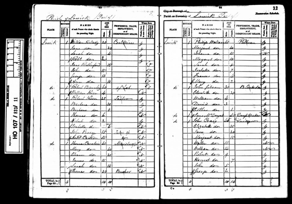
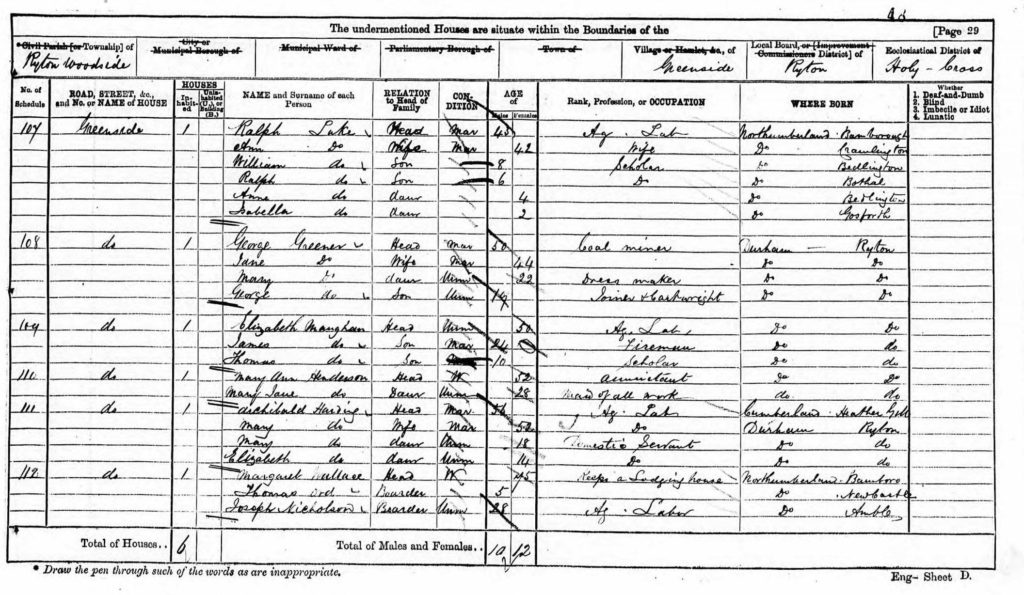

Wylam is a small village about 10 miles west of Newcastle upon Tyne close to the north bank of the River Tyne. It is located in the county of Northumberland.
The earliest reference to Wylam is in a record of 1158 that records that the settlement belonged to the priory at Tynemouth. It is thought that Guy de Balliol, Lord of Bywell, gave Wylam to the priory in 1085. The Priors of Tynemouth held lands in the village until the dissolution of the monasteries in the 16th century.
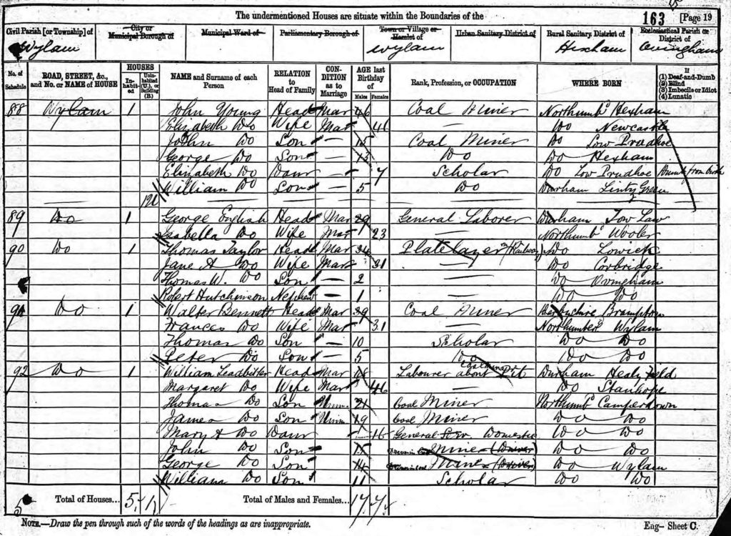
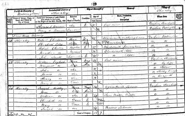
The Blackett family had a long association with the village. In 1659 Christopher Blackett acquired the Lordship of the Manor of Wylam on the death of his wife’s father, Thomas Fenwick. Following Christopher’s death, his second son, John Blackett, took over the estate and purchased additional land in the area, including two farms at Wylam bought in 1685. These farms formed a modest estate and residence for the Blackett family until the third quarter of the 20th century. The Lordship also included mineral rights within the township. This allowed the family to develop the colliery and further increase their prosperity.
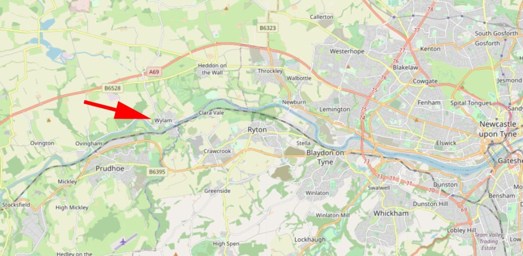
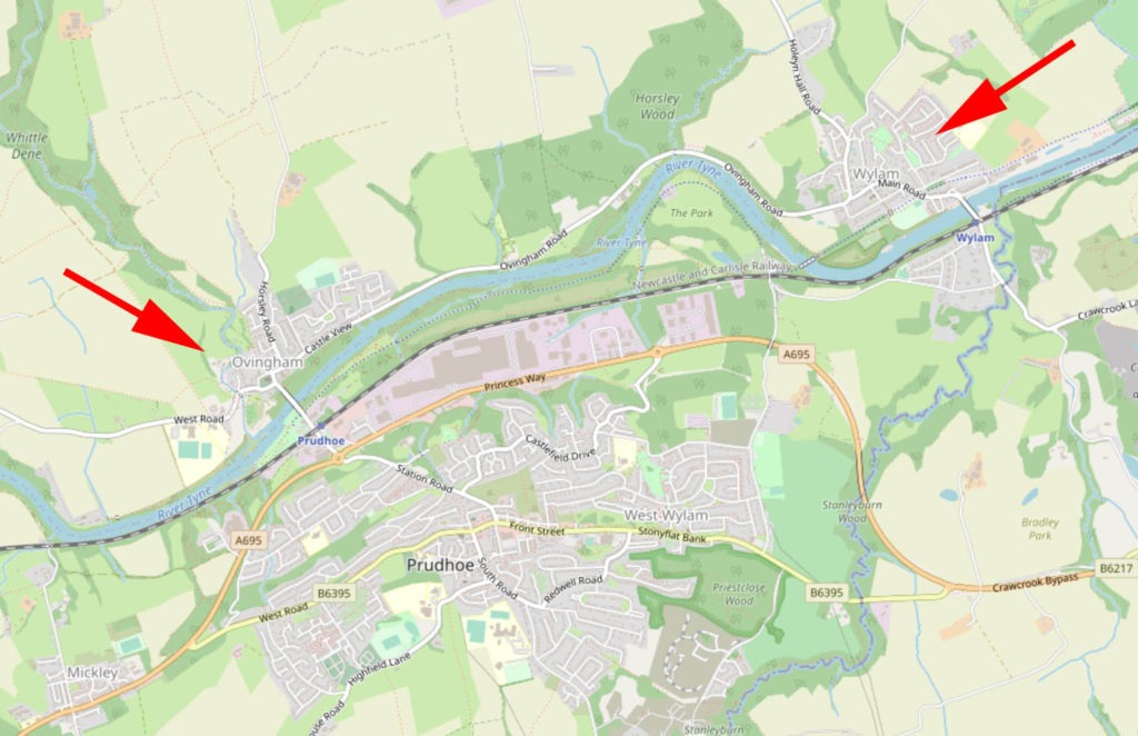
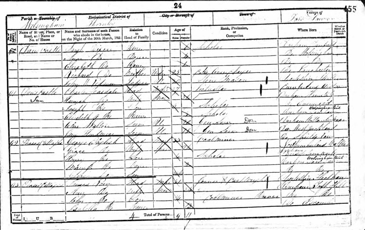
Ovingham is just over 2 miles in a westerly direction from Wylam on the River Tyne.
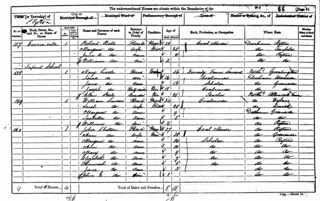
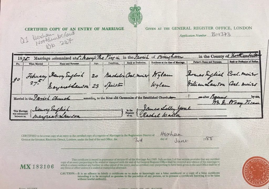
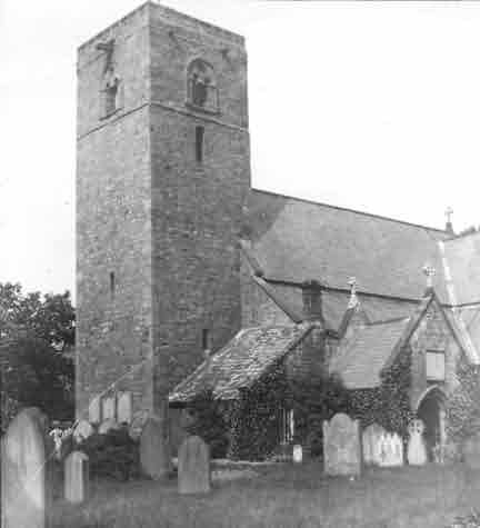
Henry and Margaret married in St Mary the Virgin Anglican Church. There was no parish church in Wylam until 1886 – St Oswin.
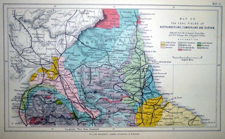
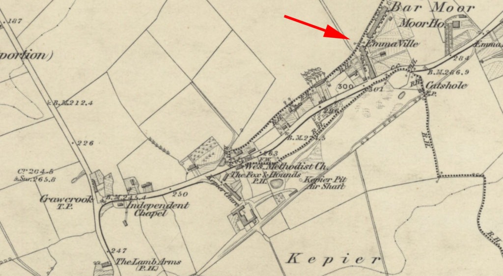
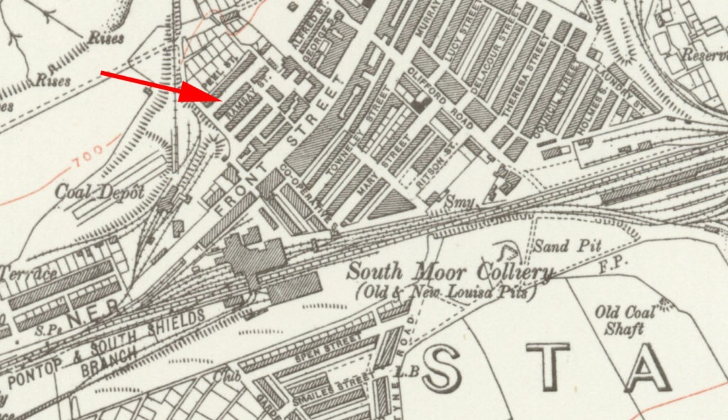
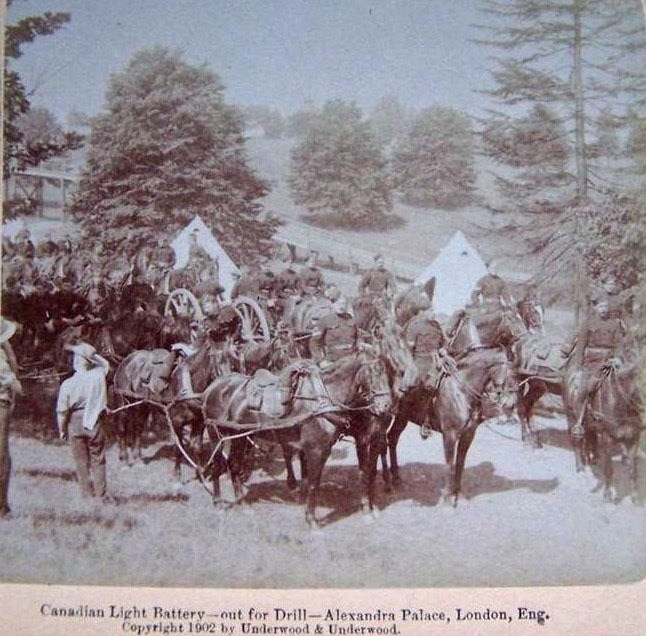
The Wylam Waggonway was built around 1748 to a five foot gauge and was used to transport coal from Wylam to Lemington (marked on the map by the red arrow) for shipment down the River Tyne. Originally the coal wagons were pulled by horses along the wooden rails. In 1808 the wooden rails were replaced with iron rails. During the period of the the Napoleonic Wars (1799 – 1815), when demand for coal was high, Mr Christopher Blackett, the owner of Wylam Colliery, wanted to improve the transport of coal. In 1812 he asked his Colliery Manager, William Hedley, to build a locomotive. Hedley produced a prototype which went into operation in 1813. By 1815 Hedley’s steam engines were established on the Waggonway pulling eight wagons as against the single wagon originally pulled by a horse.
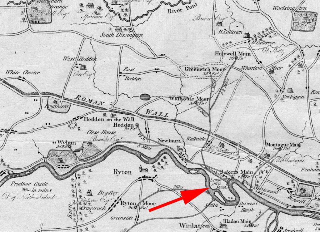
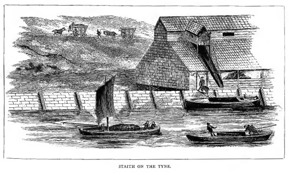
The red arrow shows Lemington Staith. A typical staith is shown below:
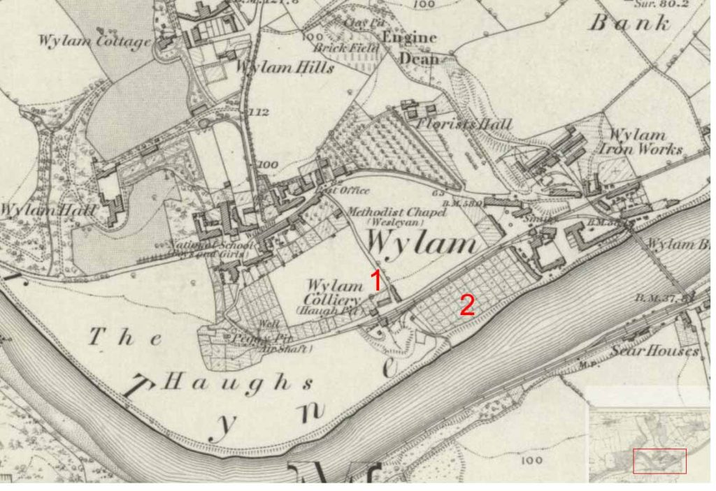
The Bumbler Box is the bridge leading down from Woodcroft Road (1 on the map) to the riverside allotments (2 on map). The name Bumbler Box was given to the old colliery and its spoil heap (now covered by trees) because it was shaped like a beehive. Bumbler Box is a common Northumberland name for a beehive.
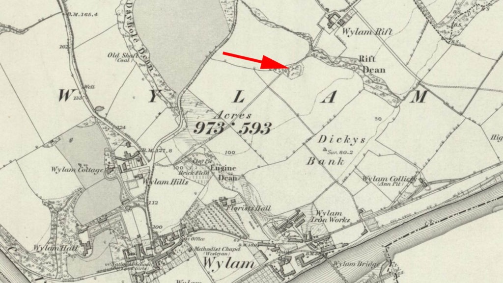
Old Hope Pit was known locally as the Chuckee Pit. This pit had been worked periodically during the 18th and 19th centuries, but eventually closed in 1893-4. Old Hope Pit was close to Wylam Rift as shown by the red arrow on this map.
During 1908 to 1910, discussions took place between representatives of the Transvaal Government and the Transvaal Chamber of Mines. As a result of which an association named the Transvaal Miners’ Phthisis (tuberculosis) Sanatorium was formed. The objectives (amongst others) were to establish an institution for the reception and treatment of miners’ phthisis or any other disease to which miners or other persons employed in mining were particularly subject to. The government donated a piece of ground, about 20 acres in extent and the buildings therein known as Springkell Sanatorium near the Modderfontein Dynamite Factory. The Transvaal Chamber of Mines erected the sanatorium in 1911. The sanatorium was for white miners suffering from phthisis.

Springkell Sanatorium was opened in November 1911 with nominal accommodation for 70 patients. The daily average number of patients for the first few years was between 45 and 50.
Patients of Springkell were encouraged to do gardening and odd jobs like bricklaying, keeping poultry, painting, tailoring and carpentry. A billiard room and bowling green were provided for entertainment.
Source: The Heritage Portal
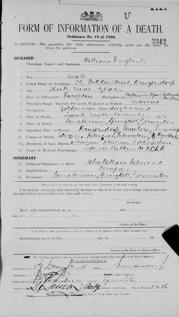
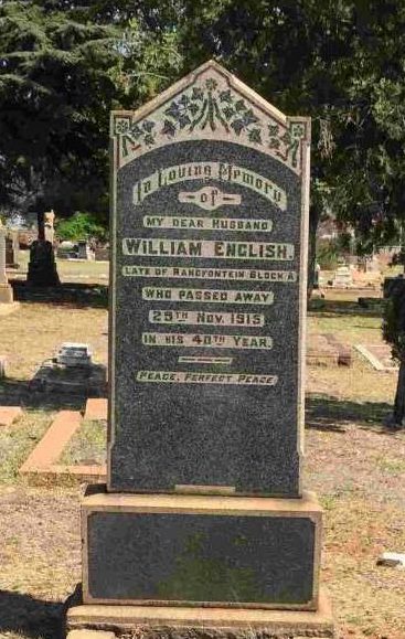
William’s health has clearly deteriorated further as he enters Springkell Sanatorium in October for what he felt was a short rest. Unfortunately he died on 29 November 1915. His death notice showed that he died at Springkell Sanatorium. William was buried at Burgershoop Cemetery, Krugersdorp.
Shimwells was a well-known cycle shop on the corner of Eloff and Pritchard Streets in Johannesburg. Within a few years of Shimwell Brothers opening their bicycle shop in 1897, cycling became something of a craze in Johannesburg.

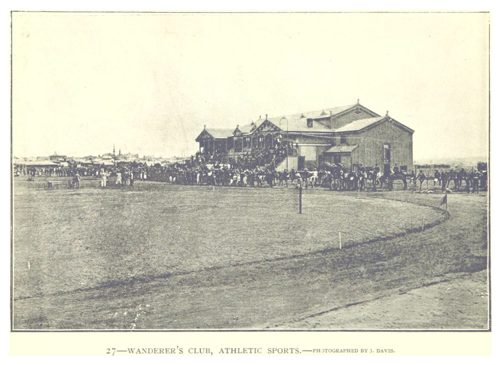
This picture shows how the Wanderers Ground looked when William first entered a race. The Wanderers Club History provides a detailed history of the ground.
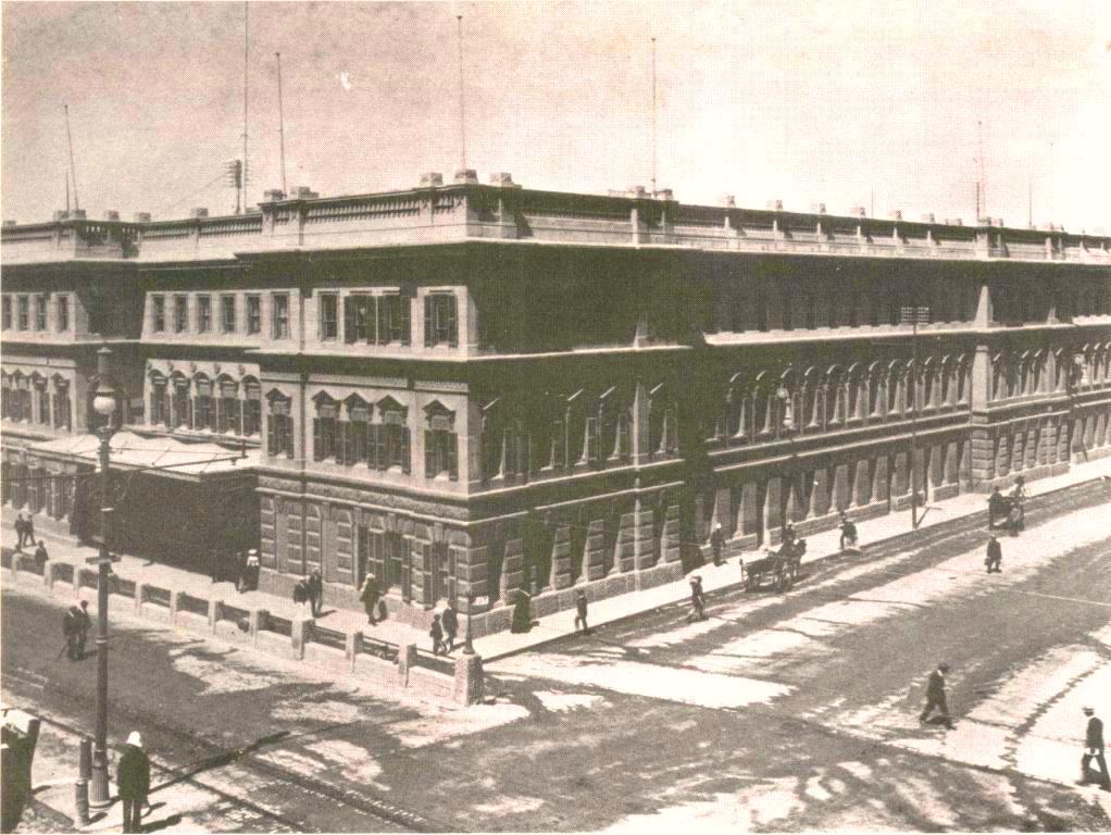
This photo shows what station looked like when William arrived at Johannesburg Park Station. The station was built in 1896.
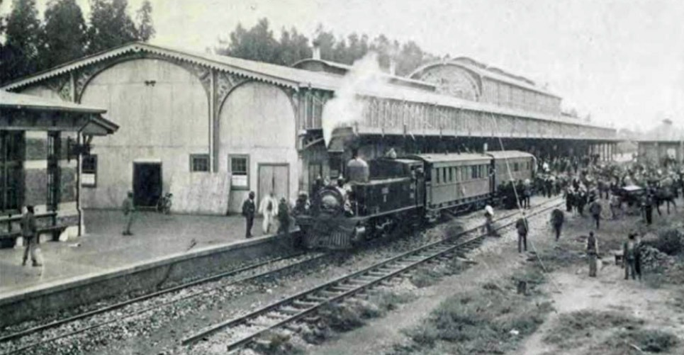
Old Park Station has more detail on the history of the station.
Johannesburg was formally established by the Boer government in 1886, after gold was discovered along the Witwatersrand reef. The town grew quickly from a mining camp of a group of tents. At the time of William’s arrival it was a rough and raw developing town with a recognisable street pattern and buildings. What did Johannesburg look like in 1889? and Johannesburg in 1900 has several photographs from this time.
The 1897 Melville map of Johannesburg shows the layout at the time of Henry and William’s arrival.
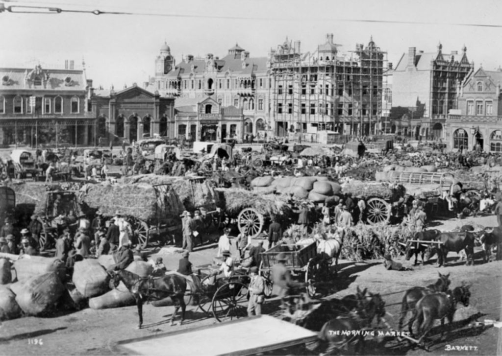
This photo provides a good impression of Market Square at this time. Market Square was the heart of the new town.

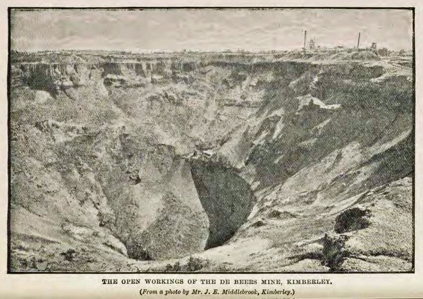
The gold mines dominated the landscape and the style of mining was changed rapidly from outcrop surface mining, with shallow incline shafts and the simple crushing of the ore to the deeper level mining.
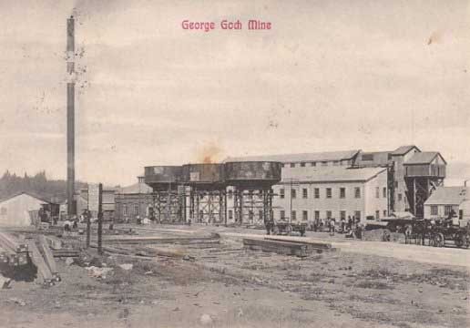
This is a picture of the mine a few years later. Discovery of the Gold in 1884 has a good description of the development of the industry.
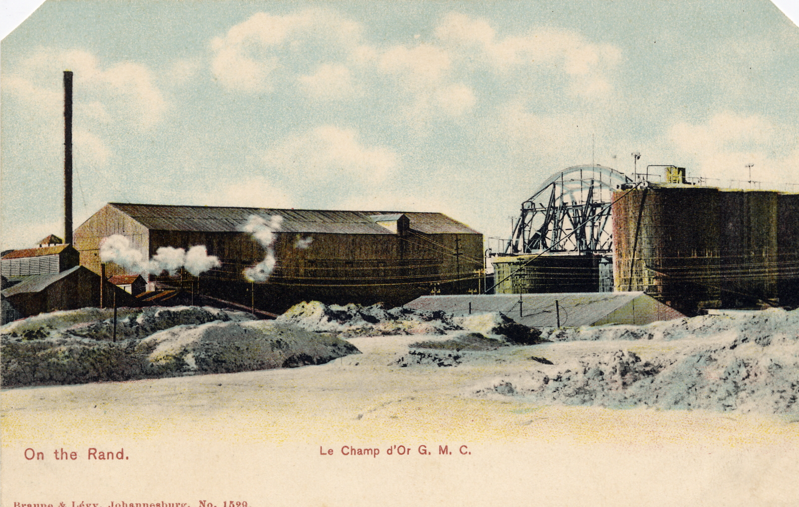
Champ d’Or mine was approximately 24km west of Johannesburg at Krugersdorp. The mine was established in 1890 by French capital. Historically mined for gold and uranium from the late 1890’s to 1960’s.

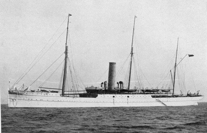
William says he travels on the Union Boat Athenium, but it is more likely to be the Union Boat Athenian.
William arrived in Cape Town and immediately left to the rail station. He would have had the briefest views of Cape Town at this time.
William talked about the accommodation on the train saying, ‘it was wooden seats for three of us’. Does he mean that there were three of them travelling together, i.e. William + two others he knew or does he simply mean a three seater for three strangers?
Ward’s Directory of Newcastle-on-Tyne, 1898 has James Cook at the Cannon Inn, The Close. The Close was a road that ran parallel with the River Tyne.
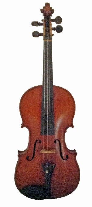
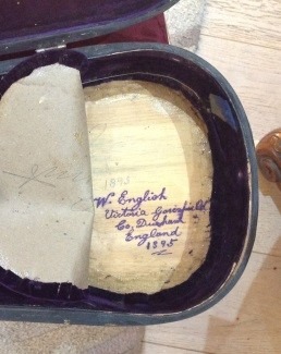
William purchases a fiddle made by Thomas Craig of Aberdeen. The violin is still with the family. The inside of the case was notated by William.
In September 1899 British forces were concentrating on the borders of South African Republic and the Republic of the Orange Free State. By the time war began nearly all Uitlanders, the mainly British migrant workers in the gold mines, left Transvaal. William described leaving Transvaal on 1 October 1899 for East London on Page 59 of the diary. South African History Online has a good description of events of this time.
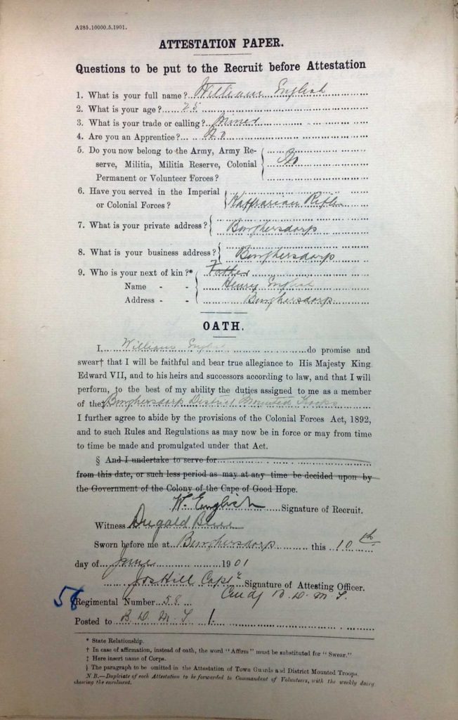
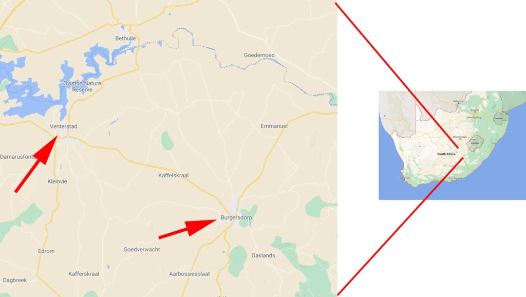
It is not clear in the original text which regiment William signed up for, but we know from attestation papers that William joined Burghersdorp Town Guards and District Mounted Troops and left on 25 Sept 1902. There were some 125 Town Guard units during the Anglo-Boer War.
William was summoned to go to work at the Cornelia Mine. The telegraph is dated 27 January 1904 and he starts work on 30th January 1904. The telegraph also confirms that he was at the Schuller Mines previously.
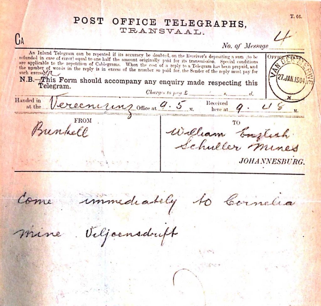
The Cornelia Mine was just south of the River Vaal. Coal was extracted from this mine. William worked there for 9 months and was living at Vereeniging. The forgotten history of the early days of coal in the Vereeniging area has more information.
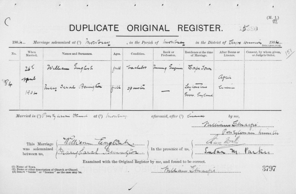
William married Mary Sarah Bevington at Mowbray Presbyterian Church in Cape Town.
The Missing Years and Mary Sarah Bevington has further clues about when they met.
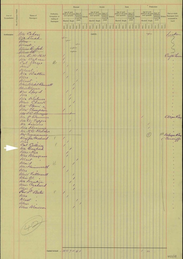
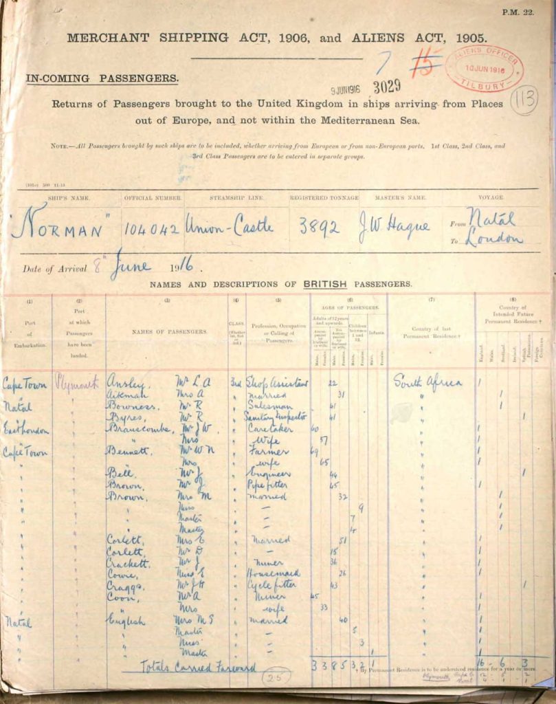
Mary Sarah English travelled to England with son Henry Bevington English on RMSS Saxon. Information from UK Incoming Passenger Lists, 1878-1960 shows that they arrive in Southampton on 16 September 1905. Presumably they are going to stay with her mother at 77 New Fillebrook Road in Leytonstone.

Information from UK Incoming Passenger Lists, 1878-1960 shows that he arrived in Southampton on 28 April 1906 and then went to Leytonstone.
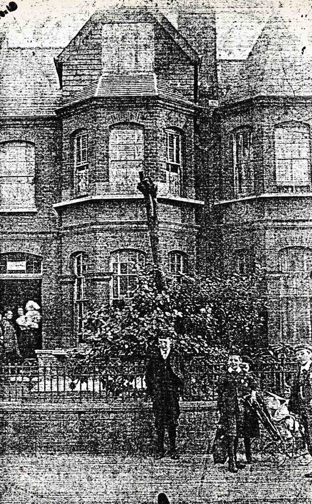
Mary Sarah’s parents Henry and Emma Bevington first moved to 77 Fillebrook Road, Leytonstone in 1890. This picture came from a member of William’s family so it is likely that the people in the doorway are relatives. It is possible that it is Marie holding Henry.
Henry died in 1894. Emma remained there until at least 1908, after which she moved to Dawlish Drive, Leigh-on-Sea, Essex.
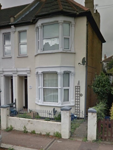
The house is 17 Cranleigh Drive, Leigh on Sea, Essex. This is known because this detail is shown on William’s entry on the roll of individuals awarded The Queen’s South Africa Medal, which was awarded to military personnel who served in the Boer War. Also, after 8 months separation Marie and William would need some privacy. The house in Cranleigh Drive would have been relatively new in 1906 as the road is not shown on Ordnance Survey County Series Essex 1898 1:10560 map.
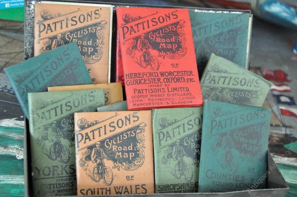
William embarks on several cycling trips including a long journey to the north east of England to see members of his family. It is believed William used a family copy of Paterson’s Roads published in 1808 which focused on the roads and direction of travel, but also included some topographical features and places of interest outside of the necessary towns and coaching inns. He may also have used some Pattison Cyclists Road Maps as well.
William’s cycle trip to North East England has more detail on William’s trip.
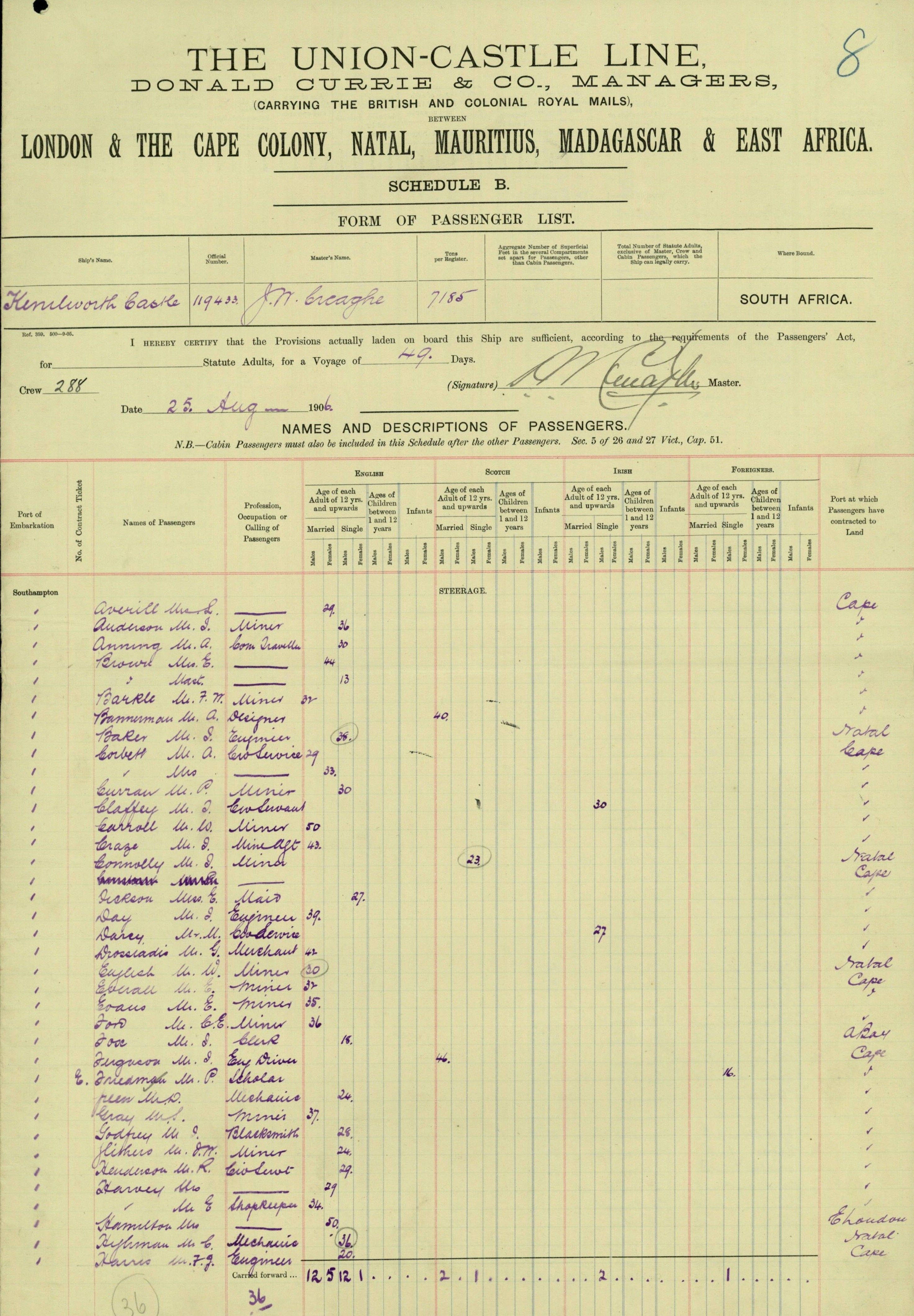
William leaves on his own to travel back to Southern Africa on the SS Kenilworth Castle.
It is interesting to speculate why his wife and son didn’t travel back with him. Did she stay behind to help her mother’s move from Leytonstone to Dawlish Drive in Leigh-on-Sea? The move occurred sometime between 1908 and 1911. Did they take a decision that the developing settlements in Transvaal were not an appropriate place to bring up a young child?
Muldersdrift is a rural area situated 13 km northeast of Krugersdorp as shown by the aerial photograph below.
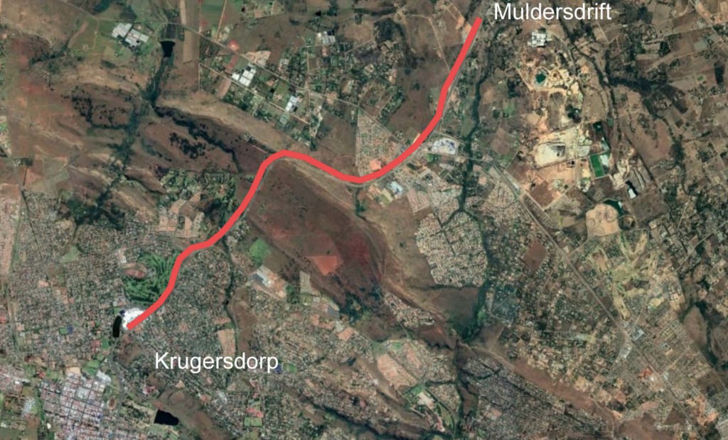
There is a clear ridge between Krugersdorp and Muldersdrift and it is most likely to be the climb that William is referring to.
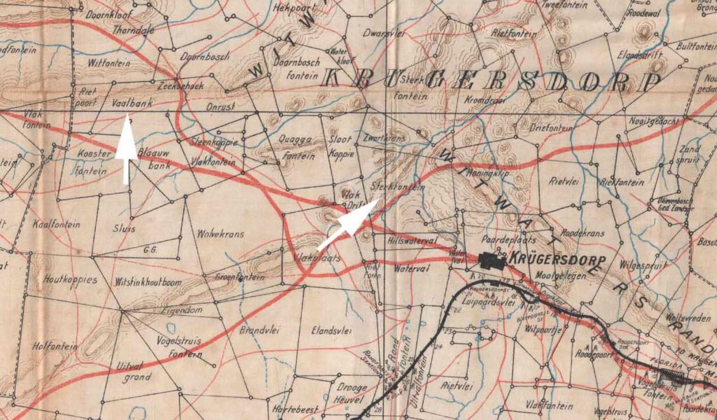
Sterkfontein Farm is shown on this 1900 of the Krugersdorp area. It is about 6 miles from Krugersdorp, close to Sterkfontein Cave Sterkfontein means strong fountain.
Henry died on 23 December 1908 and his Form of Information of Death said he was suffering from heart disease and asthma for the previous year. Was the move to the farm intended to provide work that would put him at less risk than mining. Though the Journal describes his last day underground a month later on 1st October.
Henry English died 23 December 1908 at Sterkfontein Farm.
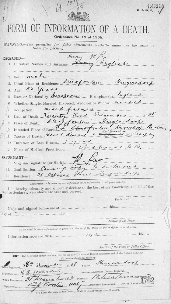
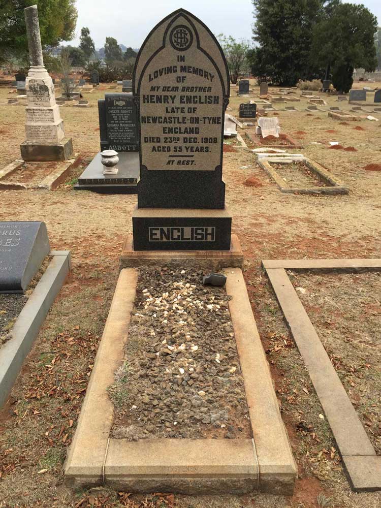
He was buried at Burgershoop Cemetery. The inscription has in memory of my dear brother. This is from his sister Mary Jane who is also in Transvaal.
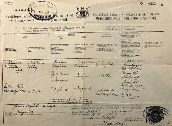
William Ridley English was born in South Africa, but he was baptised in Ovingham, Northumberland on 17 September 1911. On 15 March 1911 in the Journal William records that Marie, Henry and William travel to England and arrived in Southampton on 8 April 1911.
The initial conclusion is that Marie travelled with the two boys to Northumberland for the baptism. But there is no evidence that Marie had any previous contact with William’s family in the North East. Such a visit would probably have been daunting. On Pages 48 and 60 of the Journal William describes starting shiftbossing at Randfontein Central on 5th Feb 1911 and becoming Acting Mine Captain No 9 shaft in 1911. There is no detail for the intervening period. Did he travel to England separately? Did he join Marie, Harry and Willie and travel to the North East. So far there is no documentary evidence, but it is possible.
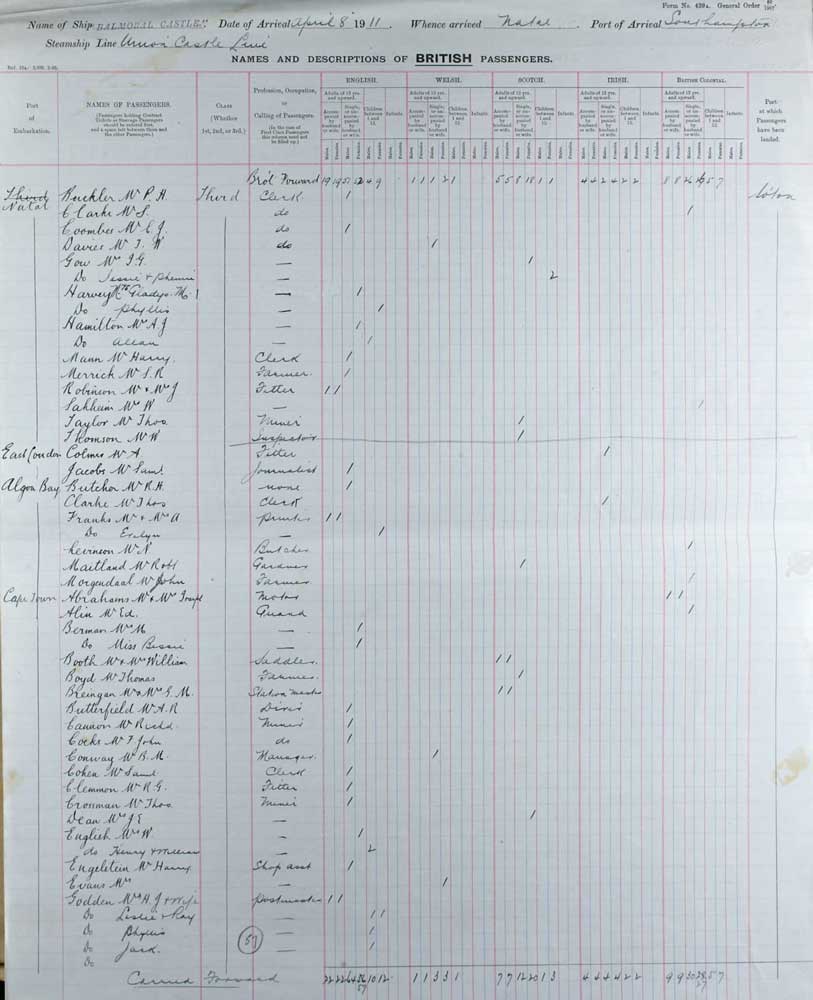
UK Incoming Passenger Lists, 1878-1960 show that Marie, Henry and Willie travelled on HMSS Balmoral Castle and arrived in Southampton on 8 April 1911.
Marie returns to Southern Africa on 1 March 1912 with only Willie Ridley. We know that Henry Bevington English attended Highfield College in Leigh-on-Sea, but not the exact dates. However, this is probably the journey where he remained in England, living with his Aunt Elizabeth Bevington and grand-mother Emma Bevington at 23 Dawlish Drive in Leigh-on-sea.
Interestingly, there is no mention in William’s diary of Marie and Willie’s return to Southern Africa.
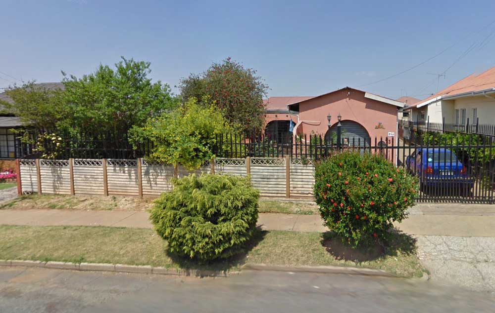
William buys a further two houses, freehold, in Krugersdorp. On Page 62 William confirms that Stand 609 is 53 and 53A Van Wyk Street. What does that tell us about his income at this time? This is a modern day street view of 53 Van Wyk Street
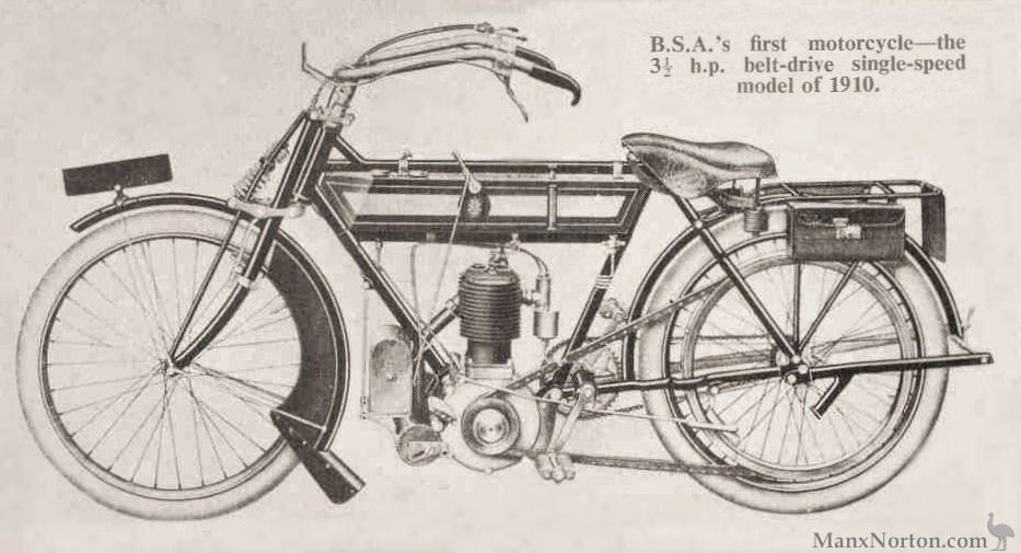
William’s bike probably looked like this model
Vaalbank Farm is shown on this 1900 map of area around Krugersdorp. It is about 18 miles from Krugersdorp.
Under the Native Land Act of 1913, 90% of land was given to white settlers. Has William benefited from this Act? Did he own the farm?

Mrs Bevington is William’s mother in law – Emma Bevington.
William’s journey to England in 1906 is recorded on the Walmer Castle passenger list.

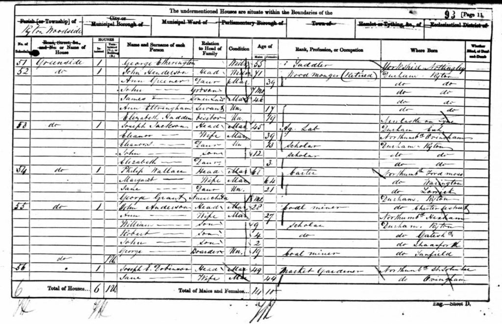
The influx of people to the newly proclaimed diggings necessitated the proclamation of a Stands Town, Krugersdorp in 1887. The first 200 stands in Krugersdorp were sold on a public auction on 31 October 1887 under a 99-year leasehold. The condition of the leasehold stated that the lessee could own the property for 99 years as long as his payment of stand fees was not in arrears. Further stands became available in later years.
It has not been possible to determine whether William was the first lessee of Stand 253.
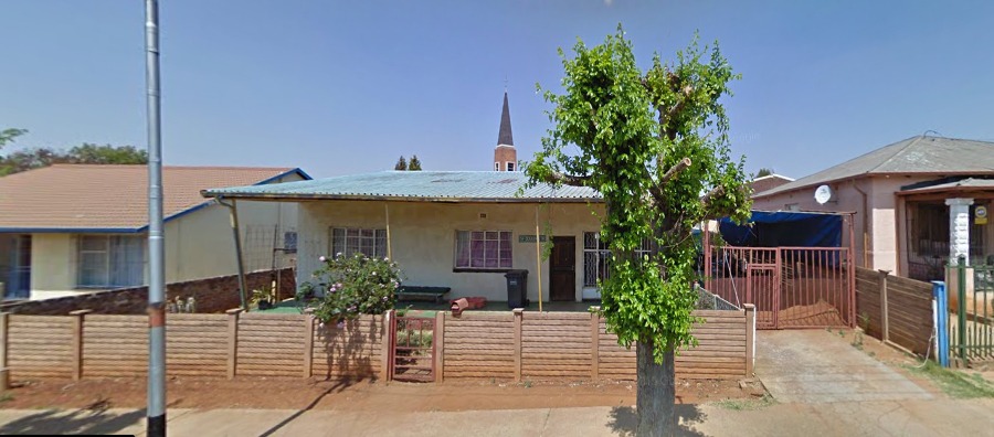
A modern day view of 59 Dekker Street. William, Marie and Henry probably moved from mine accommodation.
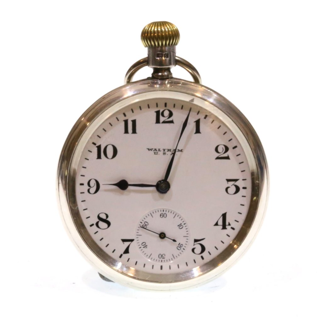
Waltham is an American company, the first to manufacture watch parts entirely by machine. Developed the Railway clock for accurate station timekeeping. Now collectors items. We don’t know exactly when William acquired his but this one’s dated 1902.
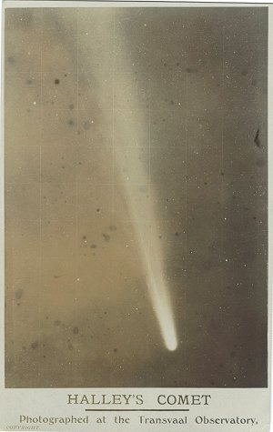
After an absence of 75 years, Halley’s Comet became visible again in southern Africa in April 1910. Public interest in the event had been heightened by the unexpected and spectacular appearance of another comet in January. Public anxiety relating to Halley’s Comet as a supposed harbinger of disaster was enhanced by the unexpected death of King Edward VII on 6 May, when the comet was at its most prominent. Despite assurances from both professional and amateur astronomers, the anxiety was focussed mainly on the night of 18-19 May, when the earth passed through the comet’s tail. As it turned out, the night passed without incident. Probably the best photographs of Halley’s Comet obtained anywhere during its 1910 return were taken by H.E. Wood, Chief Assistant at the Transvaal Observatory, with the newly installed Franklin-Adams telescope. Wood and Professor W.A. Rudge read papers about the comet at the annual congress of the South African Association for the Advancement of Science that year. The enthusiasm for astronomy resulting from the comet’s return contributed much to the movement to found the Cape Astronomical Association in 1912. South African Journal of Science
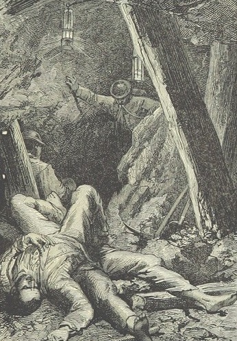
This line drawing shows a very similar scene
Contents
The Missing Years and Mary Sarah Bevington
READ MOREBefore William’s Birth
READ MOREWilliam’s Early Life
READ MOREWilliam’s cycle trip to North East England
READ MORELater Years
READ MOREAfter William’s Death
READ MOREWilliam’s move to South Africa
READ MOREBackground to William’s ‘Poems’
READ MOREWilliam’s cycle trip to North East England
Background
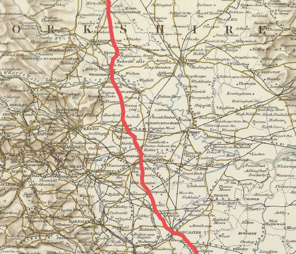
This cycle journey to north east England took place in July 1906 when WILLIAM and Marie were both in England. Marie and their son Harry arrived in September 1905 and stayed until June 1909. WILLIAM joined them in April 1906 and left at the end of August 1906. WILLIAM describes several versions of his cycle trip to the North East of England on Pages 31-34 in the Journal and in separate notes attached to it.
The two routes from London both start at Tottenham Station and go on to Boroughbridge. At Boroughbridge WILLIAM then describes two alternative routes to Crawcrook in the North East. He refers to these as Route 1 and Route 2. These routes began in London, which suggests he had been planning this trip for some time.
It is possible the idea suggested itself to him when he first stayed at 77 Fillebrook Road in Leytonstone with the Bevingtons when he arrived in England in April 1906 or that he had had a yearning to return to his birth place for many years, and came to England with the trip already in mind.
However, in the Journal, we have details of the journey he actually took to Emmaville (Route from Leigh on Sea) as well as scribbled notes itemising places to where it joins up with his original itinerary from London.
A family copy of Paterson’s Roads published in 1808, although completely out of date by 1906 when WILLIAM undertook his ride, appears to have been used for his route planning, judging by the marginalia and the references to roads leading off his route which correspond to the Paterson format e.g. St Ives to the right. He may also have owned one of the many Cycling Guides available at the time.
Routes from London
Although in the event he did not begin his epic ride in London, it is worth noting the route he planned, especially as it provides a little more information about the latter part of his journey.
It would have begun at Tottenham Station then closely follow Paterson’s pages 178/9 from Potters Bar north.
It’s a pity WILLIAM doesn’t describe how he intended to travel from Leytonstone to Tottenham then on to Wood Green, but Fillebroook Road where the Bevingtons lived was almost opposite Leytonstone Station. It is possible that WILLIAM contemplated taking his bicycle by train to Tottenham Station from Leytonstone. Although this would entail a change at Stratford, it would have been a fairly direct route enabling him to get onto the Great North Road (A1) relatively easily without having to negotiate the maze of roads around Low Leyton, Leyton Green and the Marshes.
From Tottenham Station, WILLIAM would have made his way to Wood Green via Bruce Grove and Lordship Lane, then, either via Palmers Green and Alderman’s Hill or via Bounds Green, to Southgate. From here the equivalent of the modern A111 and A1000 would have taken him to Potters Bar and Hatfield where he would have joined the Great North Road. This stage of the proposed journey corresponds with pages 178/9 of Paterson.
(WILLIAM planned to continue north on the A1, but to follow his route today one would need a diversion at Hitchen, because of the changes in road layouts, first onto the A600, then the A602, before re-joining the A1 near Biggleswade.)
In WILLIAM’S list an arrow indicates straight ahead →
It is not clear what WILLIAM means when he says ‘or right‘ or ‘or left‘ in conjunction with ‘straight ahead‘. Does he have alternative routes in mind or is he simply indicating there are other roads?
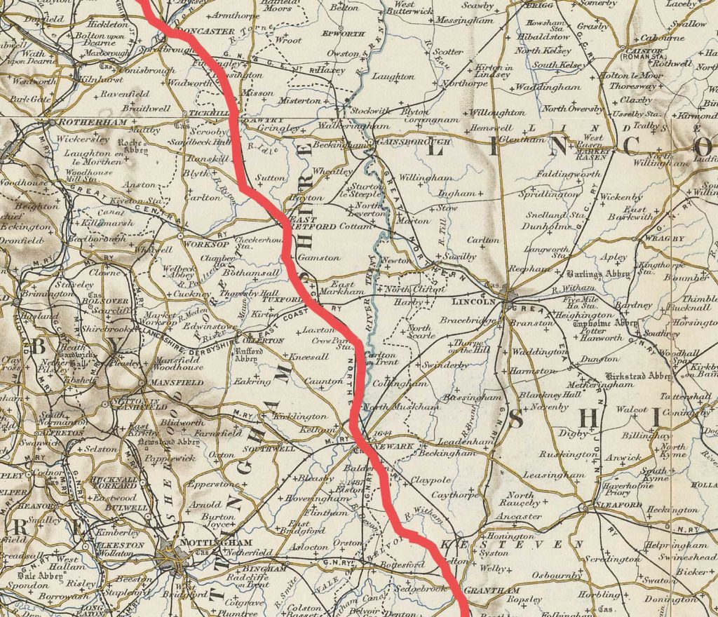
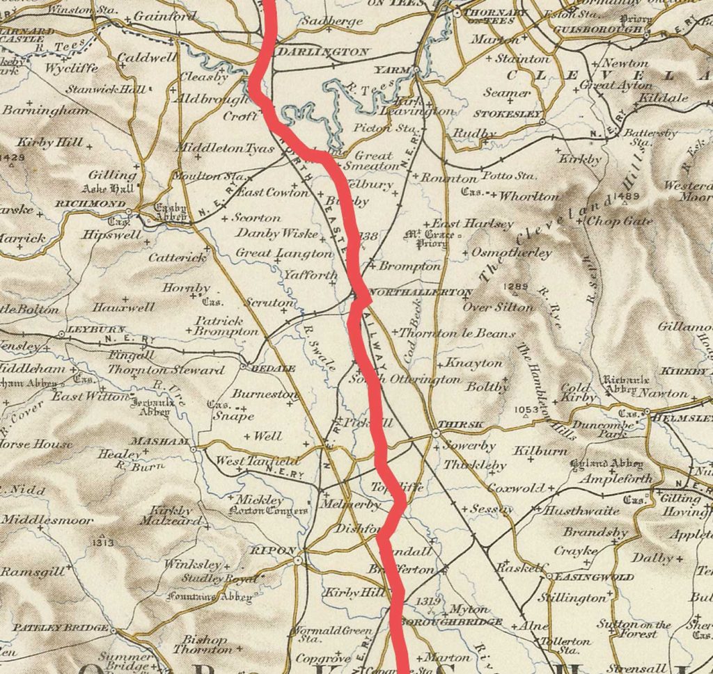
Both routes closely follow the modern A1 and A167 after Alconbury, north to Durham, although it is clear that the state of the roads is pretty poor especially on the outskirts of large towns. At Darlington WILLIAM ‘took some time to find the road through here‘ and he had ‘a struggle‘ to find Durham. ‘Retford is paved‘ is underlined! Worthy of several exclamation marks today.
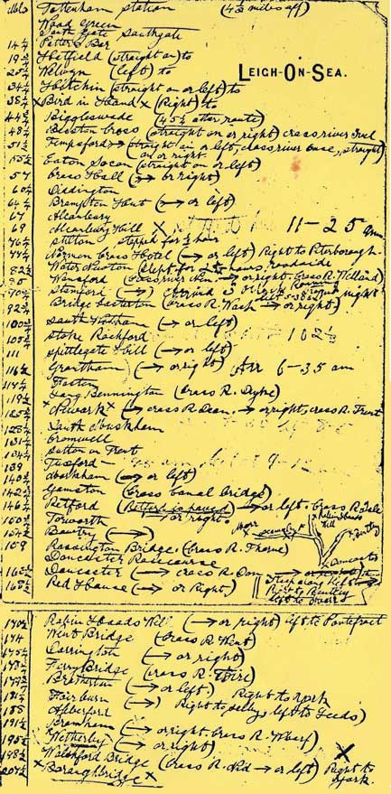
London to Boroughbridge
We have WILLIAM’S original notes for this route. The transcribed version is below:
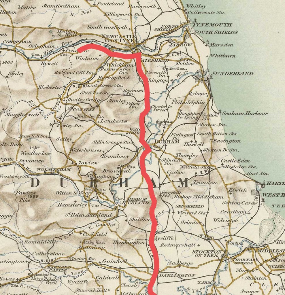
Boroughbridge to Crawcrook Route 1
WILLIAM’S original notes for this route can be seen at Boroughbridge to Crawcrook Route 1. The transcribed version is below:
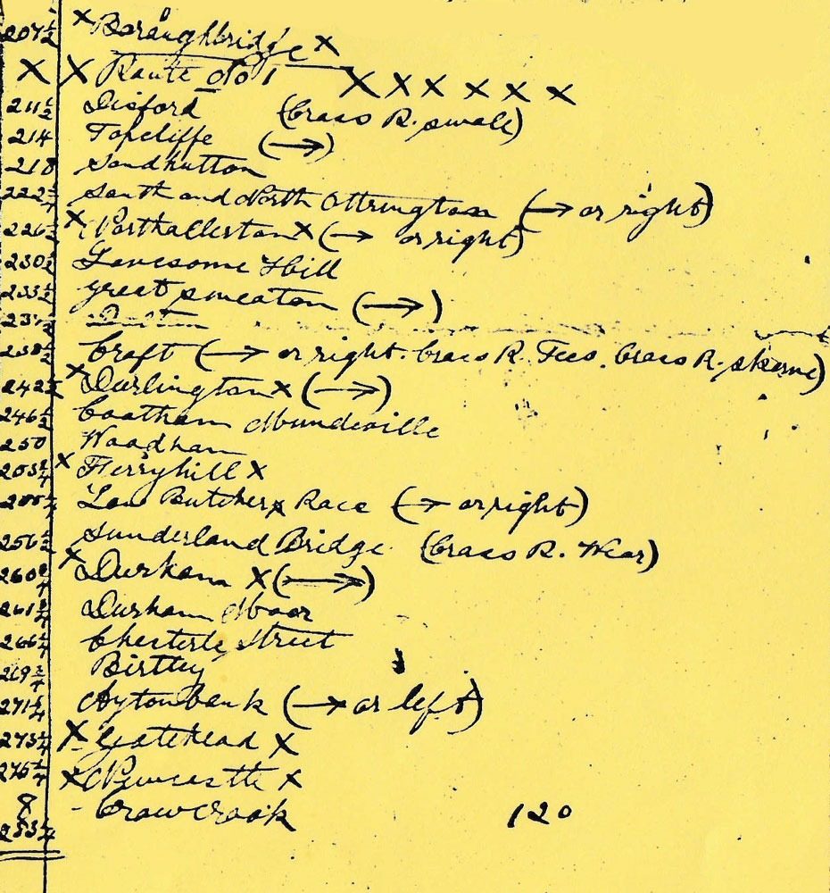
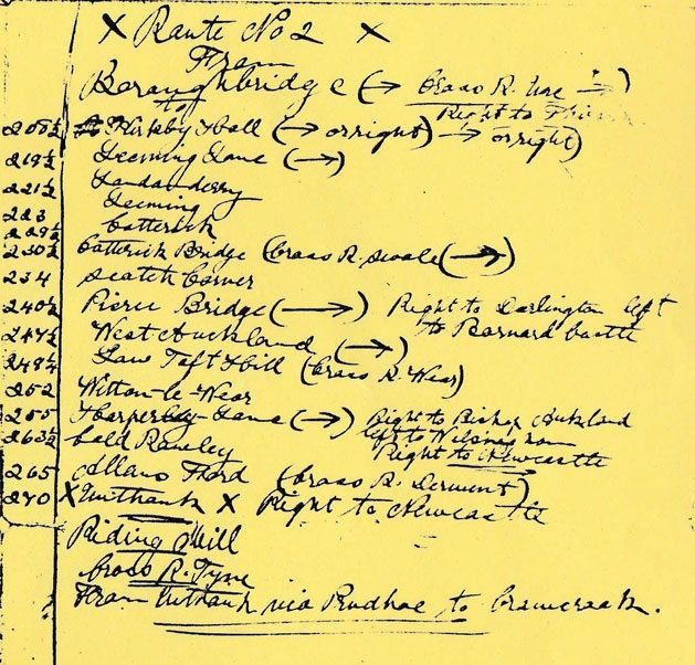
Boroughbridge to Crawcrook Route 2
This is WILLIAM’S alternative route from Boroughbridge to Crawcrook. WILLIAM’S original notes for this route can be seen at Boroughbridge to Crawcrook Route 2. The transcribed version is below. This is also the route he chose to return home to London. See: The Return Journey
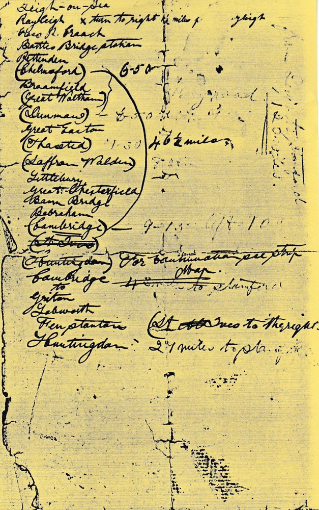
Route from Leigh on Sea
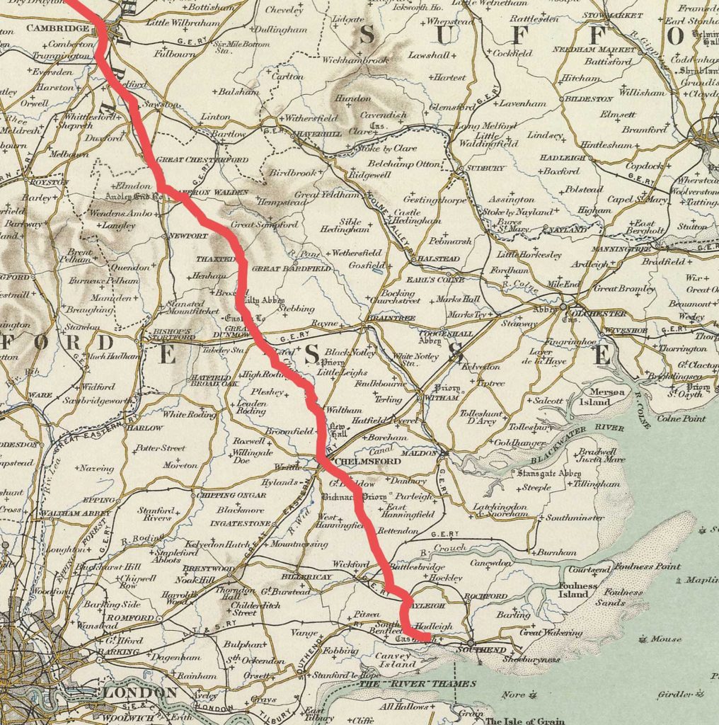
This is the amended route he eventually took from Leigh on Sea where he and Marie were staying in England in July 1906 and is based on Pages 31-34 from the Journal and additional scribbled notes on a separate page. The complete route is shown on the map below:
The links below have detailed individual sections of the route on the 1904 Ordnance Survey map. The road system shown would be as when WILLIAM completed his trip.
Detail is sparse for the first leg of the journey from Leigh to Huntingdon. Mileage is marked for Chelmsford to Cambridge – 46½ miles, but the list is interesting for the places he puts in brackets; it seems likely he rode straight through them to save both miles and time.
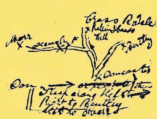
The scribbled notes
WILLIAM’S original notes for this route can be seen at Route from Leigh on Sea – The scribbled notes. The transcribed version is below. The list is as follows:
Leigh on Sea
Rayleigh x turn to the right 1 ½ miles from Rayleigh
Cross R Crouch
Battles Bridge Station
Rettenden
(Chelmsford) 6-5 [6.05]
Broomfield
(Great Waltham)
(Dunmow) 6
7.50am [Altered by William]Great Easton
(Thaxted) 7.30
(Saffron Walden) 8.00
Littlebury
Great Chesterfield
Bourn Bridge
Babraham
(Cambridge) 9.15am left 10am
From Leigh on Sea to Cambridge he appears to have used Paterson’s Cross Roads p 349 (Chelmsford to Cambridge via Dunmow and Saffron Walden.) This equates to the modern A130.
From Leigh on Sea the only route to Chelmsford was via Hadleigh, Raleigh and Battlesbridge where the River Crouch could be crossed, otherwise it would entail a detour via Wickford. He could have crossed the Crouch at Hullbridge but might not have wanted to trust the Ferry.
WILLIAM has marked the distance between Chelmsford and Cambridge as 46½ miles. He appears to have forgotten to check his watch at times so has overwritten them afterwards.
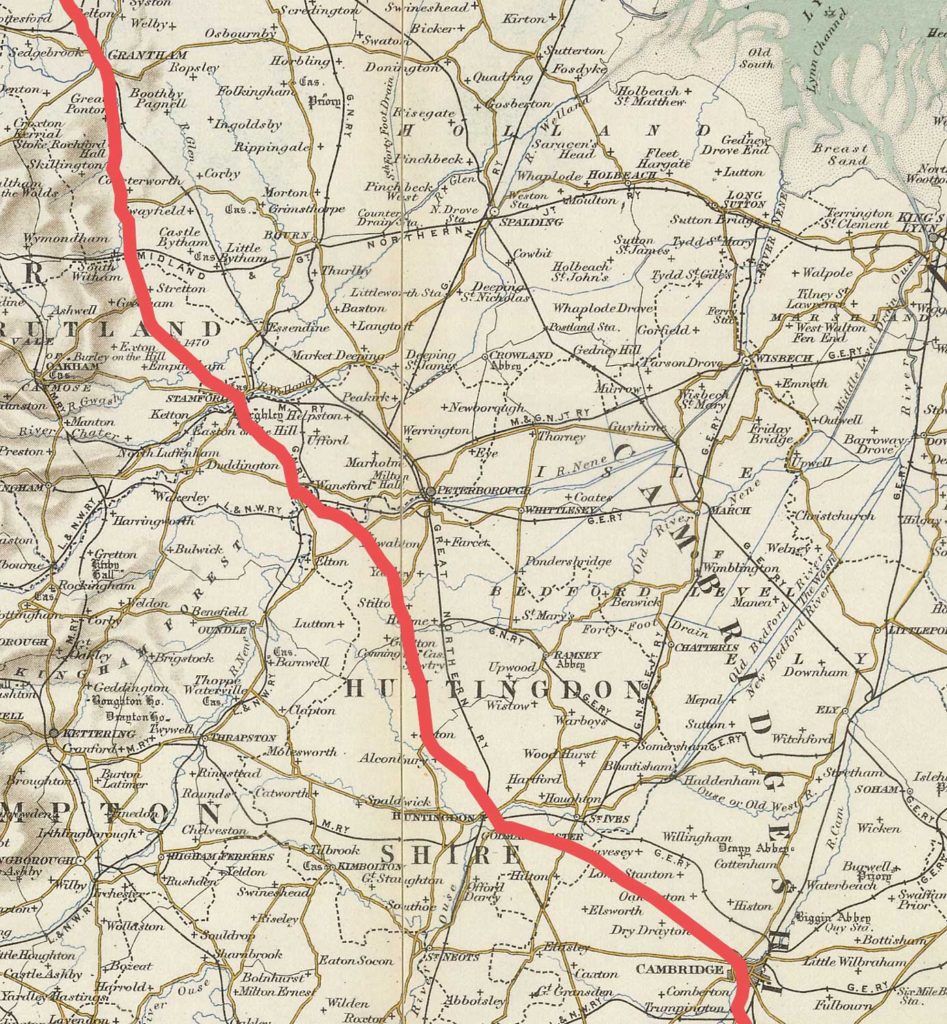
(St Ives)(Huntingdon)For continuation see strip mapCambridge
43 miles to StamfordTo
Girton
Labworth
Fenstanton (St Ives to the right)
Huntingdon 27 miles to Stamford
Once past Cambridge he seems to have used Patersons Cross Roads pages 308/9 in reverse. This was the Birmingham to Harwich Road, the modern A604.
Just past Huntingdon, at Alconbury, his route joins the London to Carlisle/ Edinburgh Road. The Great North Road (modern A1.)
The Great North Road continues to Stamford (Paterson’s p247 and/or pp 180/183.) In the margin at Norman Cross he has written ‘to 38’. Its meaning isn’t clear except that Norman Cross is where his routes meet.
There is scant detail until he reaches Alconbury where the routes converge. Stamford he admires, but even so he then manages to transport us all the way to Gateshead at break neck speed in one paragraph!
From the Journal
This is the outward journey taken by WILLIAM from Leigh on Sea to Newcastle on Tyne as actually recorded in the Journal. It is about 325 miles via Chelmsford, Huntingdon, Stamford bridge, Doncaster, Durham. The scribbled notes were probably written as he completed the journey and the pages in the Journal completed at a later date.
The return journey
On page 220 (London to Durham by Boroughbridge, Catterick and Bishop Auckland) Paterson has the following advice:
‘The adjoining road from Boroughbridge to Durham, which is always in good repair, is preferred by many travellers to the Northallerton road. – The stages from Boroughbridge are, to Leeming Lane 12m; Catterick Bridge 11m; Pierce Bridge 11 m; Bishops Auckland 10 m; and Durham 10 m.’
This is WILLIAM’S original Route 2, but in reverse
Having travelled north via Northallerton and losing his way several times between Darlington and Durham, WILLIAM could have expected his route south to be easier. He states his route will be Unthank, Pierce Bridge, Leeming Lane then onto the road south at Boroughbridge, but of course he doesn’t follow Paterson in reverse. Instead he heads west, probably intending to find the equivalent of the modern A68. His road would have gone through Prudhoe, Stocksfield and Riding Mill before turning south towards Unthank and eventually meeting The Great North Road (present day A1) at Scotch Corner.
Before the Derwent Reservoir was built in the 1960s this must have been a remote, featureless place so it is hardly surprising WILLIAM lost his way. Roads would have been bad especially after rain and he tells us that 40 out of the 80 miles covered were in driving rain. The present A68 passes quite close to Consett but it seems likely that WILLIAM took a wrong turning at Carterway Heads and headed east towards Shotley Bridge and Consett rather than crossing the Derwent at Allensford and progressing to Piercebridge, Leeming Lane and Boroughbridge. He reckoned that his detour had put an extra 18 miles on his journey, meaning he was three hours later than expected reaching Boroughbridge.
Robin Hood’s Hill is an area straddling the Great North Road about halfway between Doncaster and Pontefract. This is where he had a puncture.
Once on the Great North Road William arrived in Doncaster at 6pm and stayed the night in a Temperance Hotel. He left at 9am the following morning after a good breakfast and seems to have had a straight run to Hatfield. He branched off at Potters Bar for Tottenham and after negotiating a maze of streets, arrived Fillebrook Road in Leytonstone at 8pm.
He seems to have received cold comfort at Fillebrook Road; ‘had a small biscuit there’ but he is hungry, so when he left at 9pm he ‘bought half a dozen bananas and a packet of biscuits and eat the lot’. One wonders where he’d have a found a shop open at 9pm as late night shopping feels a very modern idea! So too does the idea of being able to find a cup of tea at half past ten at night, which he does at Stanford le Hope.
The last 40 miles home took him 2 hours 15mins which means he arrived back in Leigh in the dark. He must have followed the ‘Old London Road’ (Modern A13) via Ilford, Barking, Dagenham, Rainham, Wennington, Avely, Stifford, Baker Street, Orsett, Horndon on the Hill, Stanford le Hope, Vange, Pitsea, and Hadleigh, although he does not list his route in the Journal.
In spite of the A13 having been much widened and straightened to bypass villages, his route can be followed on OS Landranger Maps 177 (East London) and 178 (The Thames Estuary) where many sections of the old road can still be seen.
Dating the trip
WILLIAM first visits Leigh on Sea for five days in May 1906, but doesn’t supply any further information.
In July WILLIAM said, ‘Took a house at Leigh’, this is 17 Cranleigh Drive, Leigh on Sea. This is known because the address is shown on WILLIAM’S entry on the roll of individuals awarded The Queen’s South Africa Medal. The house would have been relatively new and it is possible it was a holiday let. It seems strange however that they should have preferred a suburban street to the buzz of a seaside town, Southend.
WILLIAM provides no further dates until he tells us he sailed back to South Africa on 25th August. After his journey north he provides us with a great deal of detail about his cycling exploits in Essex which rather suggests his visit was in July, after they took the house in Leigh.
We know from the Perpetual Calendar that 1st July 1906 was a Sunday.
Once in Durham he gives us only four pieces of dating information. We know what he does on the Friday, Saturday and Sunday before his departure for the South on Monday.
Working back, he appears to have been away from home for just two weeks, meaning he probably left Leigh on Monday 9th July and returned on 23rd.
If so, his itinerary was probably as follows:
Obviously from the scant information we have this can only be conjecture, but a Monday start does seem the most possible. The 16th and 23rd July are equally likely start dates, returning on the 30th July and 6th August respectively.